NASA Flights Link Methane Plumes to Tundra Fires in Western Alaska

NASA Flights Link Methane Plumes to Tundra Fires in Western Alaska

In Brief: Methane ‘hot spots’ in the Yukon-Kuskokwim Delta are more likely to be found where recent wildfires burned into the tundra, altering carbon emissions from the land. In Alaska’s largest river delta, tundra that has been scorched by wildfire is emitting more methane than the rest of the landscape long after the flames died, … Read more

NASA-ISRO Radar Mission to Provide Dynamic View of Forests, Wetlands

NASA-ISRO Radar Mission to Provide Dynamic View of Forests, Wetlands

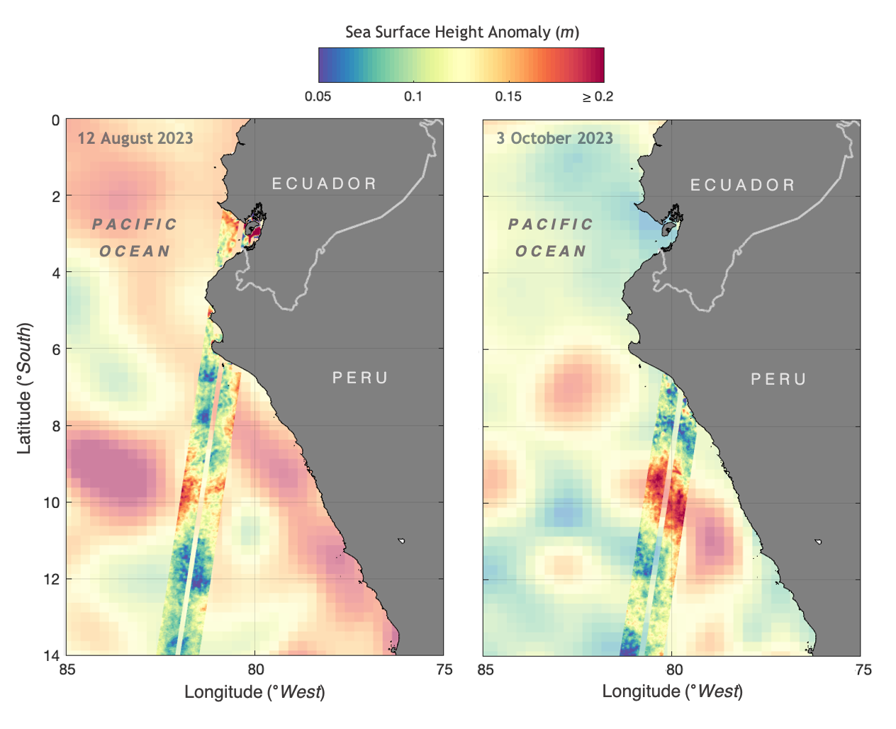
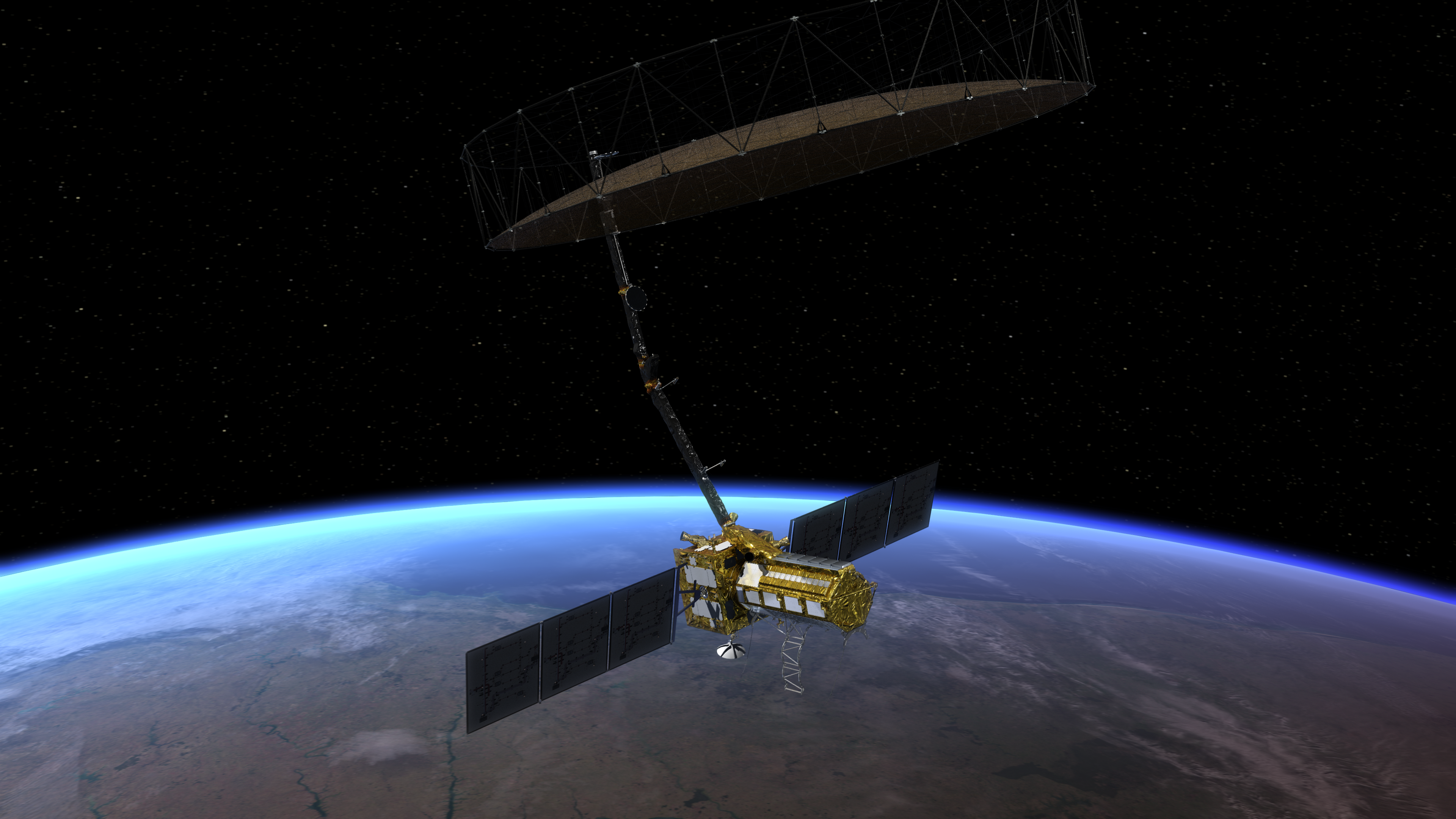
In Brief: NISAR will help researchers explore how changes in Earth’s forest and wetland ecosystems are affecting the global carbon cycle and influencing climate change. Once it launches in early 2024, the NISAR radar satellite mission will offer detailed insights into two types of ecosystems – forests and wetlands – vital to naturally regulating the … Read more

NASA-Led Study Pinpoints Areas of New York City Sinking, Rising

NASA-Led Study Pinpoints Areas of New York City Sinking, Rising

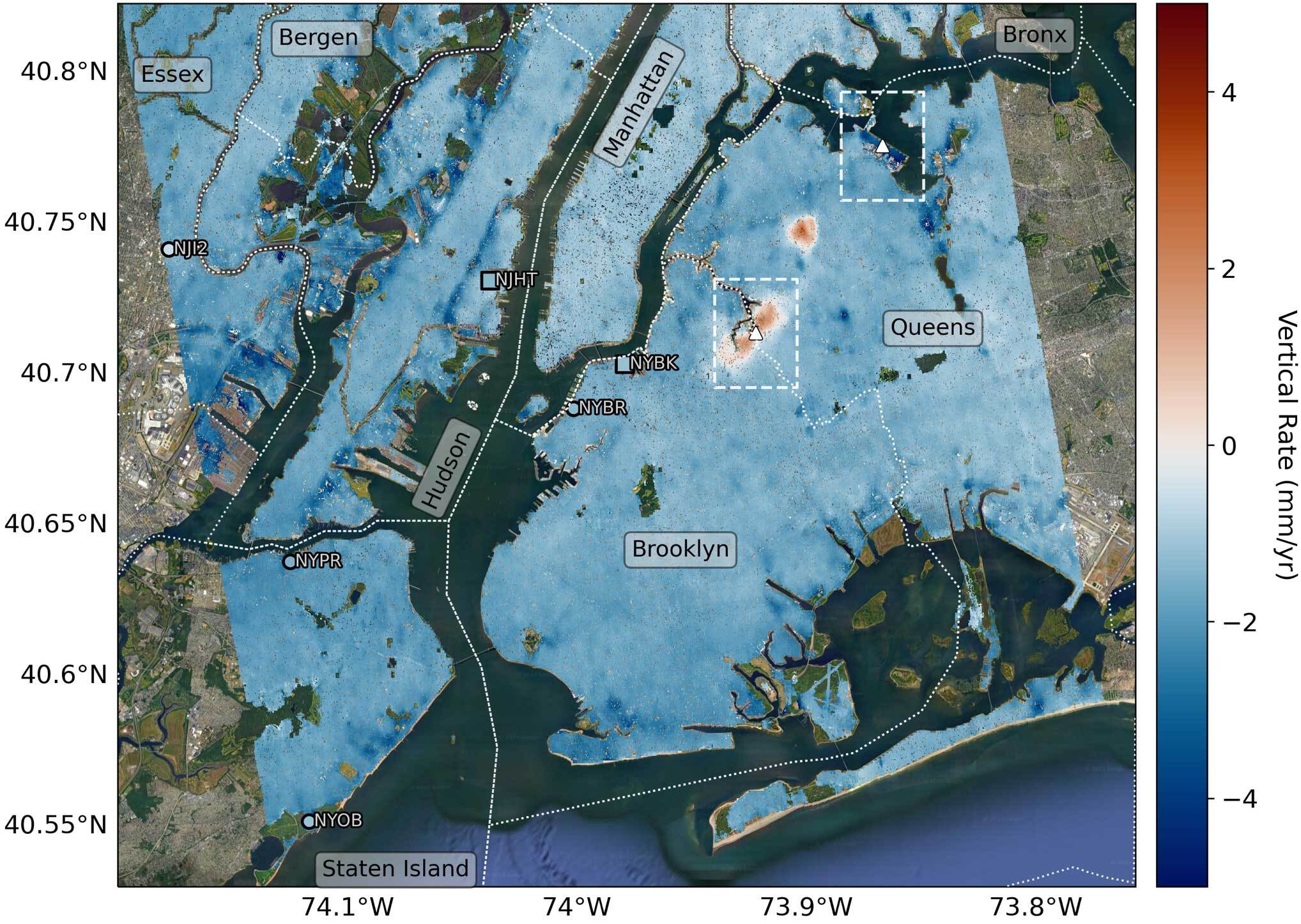
In Brief: Scientists using space-based radar found that land in New York City is sinking at varying rates from human and natural factors. A few spots are rising. Parts of the New York City metropolitan area are sinking and rising at different rates due to factors ranging from land-use practices to long-lost glaciers, scientists have … Read more

How hot will it get?

How hot will it get?

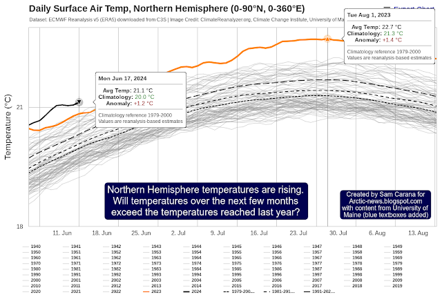
Currently, the temperature in the Northern Hemisphere is higher than it was last year at this time of year, as illustrated by the image below, created with University of Maine content. The image shows that a temperature of 21.1°C was reached in the Northern Hemisphere on June 17, 2024. The question is: Will temperatures over the next … Read more

Arctic Sea Ice Alert

Arctic Sea Ice Alert

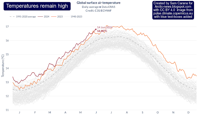
[ click on images to enlarge ] Temperatures remain high, as illustrated by the above image, adapted from Copernicus.  Meanwhile, El Niño is no longer prevalent. Instead, La Niña conditions are expected to be dominant soon, as illustrated by the NOAA ENSO update on the right.  There are fears that self-amplifying feedbacks have taken over … Read more

Have feedbacks taken over?

Have feedbacks taken over?

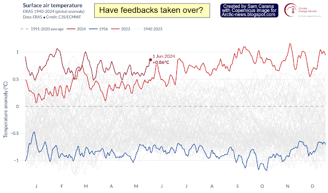
For about one year now, global temperature anomalies have been extremely high, as illustrated by the image below, created with a screenshot from Copernicus, showing an anomaly from 1991-2020 of 0.86°C on June 1, 2024. What could be behind these persistently high temperatures? Many causes such as El Niño and sunspots have been discussed in earlier … Read more

Very high temperatures in Tropics

Very high temperatures in Tropics

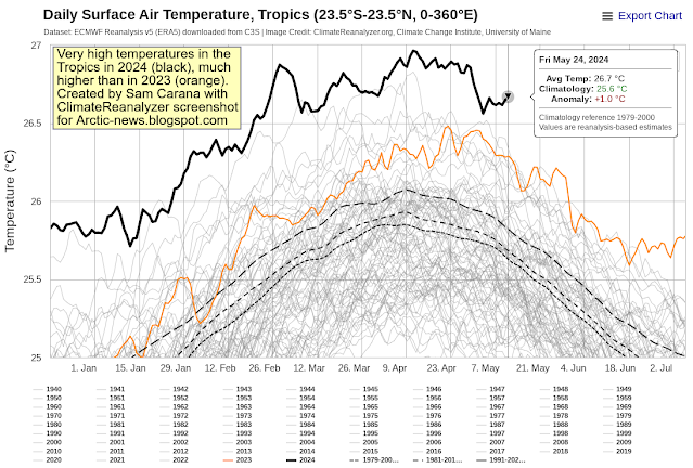
Temperatures in the Tropics (23.5°S-23.5°N, 0-360°E) have been very high in 2024 (see black line, image below), much higher than they were at this time of year in 2023 (orange line).  The above image shows that on May 24, 2024, the temperature was 26.7°C (or 80.06°F), an anomaly of 1°C (or 1.8°F) compared to 1979-2000.  The image … Read more

Temperatures in the Tropics

Temperatures in the Tropics

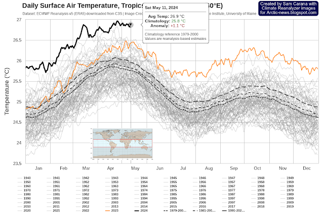
The image below shows that temperatures in the Tropics (23.5°S-23.5°N, 0-360°E) were very high during the second half of April 2024, and these very high temperatures were sustained during the first part of May 2024. The temperature was 26.9°C (or 80.42°F) on May 11, 2024, an anomaly of 1.1°C (or 1.98°F) from 1979-2000.  The image below shows … Read more

Temperature rise may soon accelerate even more

Temperature rise may soon accelerate even more

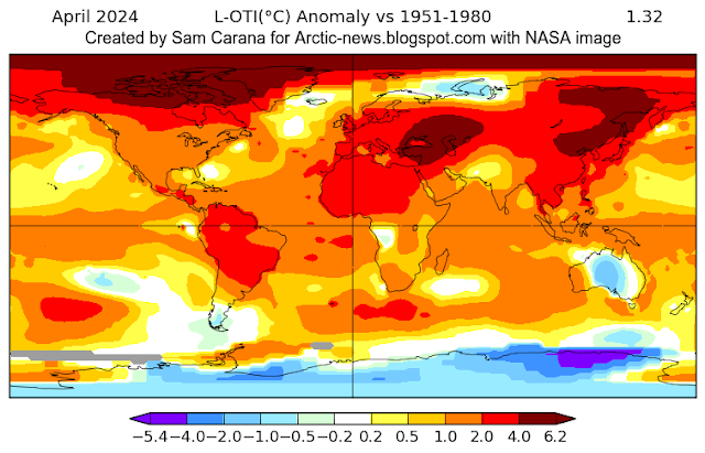
The April 2024 temperature was 1.32°C higher than 1951-1980, as illustrated by the above image, created with NASA content. Local anomalies are as high as 6.2°C. The April 2024 temperature was 1.62°C higher than 1900-1930, as illustrated by the above image, created with NASA content. The red line highlights acceleration of the temperature rise (Lowess Smoothing).  The … Read more