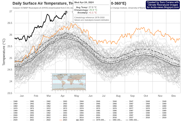
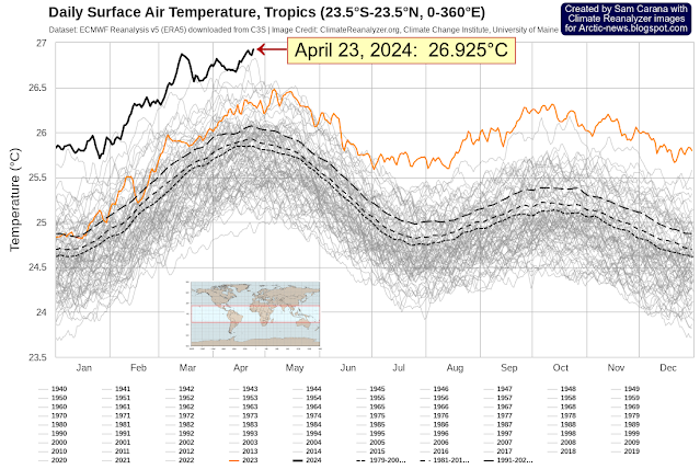
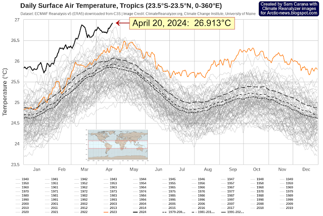
Temperature rise may soon accelerate even more

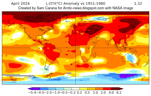
The April 2024 temperature was 1.32°C higher than 1951-1980, as illustrated by the above image, created with NASA content. Local anomalies are as high as 6.2°C. The April 2024 temperature was 1.62°C higher than 1900-1930, as illustrated by the above image, created with NASA content. The red line highlights acceleration of the temperature rise (Lowess Smoothing).  The … Read more

Tracking toward mass extinction

 by Andrew Glikson Where “Two plus two equals five if the party says so” (George Orwell)and when drilling methane wells reduces global warming Having turned a blind eye to climate science, ignoring the evidence that extreme atmospheric carbon dioxide (CO₂), methane (CH₄) rise and ocean acidification have led to mass extinctions of species through time, humanity … Read more

Is CMIP6 SSP585 the worst-case scenario?

The image below, adapted from Climate Reanalyzer, shows the temperature in the year 2100, in a CMIP6 SSP585 scenario. The image shows how much the temperature will have risen in 2100, at 2 meters above the surface and compared to the period 1979-2000.  The image below shows a progressive temperature rise reaching 4.589°C in 2100 … Read more

Temperature rise in the Tropics (update 5)

The temperature in the Tropics (23.5°S-23.5°N, 0-360°E) reached a new record high on April 24, 2024 of 27°C (or 80.6°F).  The image below shows the monthly temperature anomaly over the past few years through March 2024, when the anomaly reached a record high of 1.448°C (or 2.606°F).   Note that the anomaly in the top image … Read more

Arctic sea ice under threat

The image below indicates that Arctic sea ice volume has meanwhile passed its annual maximum. Over the coming months, volume can be expected to decrease rapidly. The image also highlights that, over the past few months, Arctic sea ice volume has been the lowest on record for the time of year. The image below illustrates … Read more

Temperature rise in the Tropics (update 4)

The temperature in the Tropics (23.5°S-23.5°N, 0-360°E) reached a new record high on April 23, 2024 of 26.925°C (or 80.47°F).  The image below shows the monthly temperature anomaly over the past few years through March 2024, when the anomaly reached a record high of 1.448°C (or 2.606°F).   Note that anomalies in the above image are … Read more

The Orwellian rules-based Climate

By Andrew Glikson “History is a nightmare from which I am trying to wake” (James Joyce) Figure 1. Extinctions CC from: The five mass extinctions in Earth History. The rate of the current rise of greenhouse gas levels and thereby temperatures is higher by more than an order of magnitude than that of previous mass extinctions. … Read more

CO2 keeps accelerating

The Scripps Institution of Oceanography, UC San Diego, reported a daily average carbon dioxide (CO₂) at Mauna Loa, Hawaii, of 428.63 parts per million (ppm) on April 26, 2024, as illustrated by the image below.  This is the highest daily average on record at Mauna Loa, which is the more remarkable since the annual CO₂ … Read more

Temperature rise in the Tropics (update 3)

The temperature in the Tropics (23.5°S-23.5°N, 0-360°E) reached a new record high on April 20, 2024 of 26.913°C (or 80.44°F).  The image below shows the monthly temperature anomaly over the past few years through March 2024, when the anomaly reached a record high of 1.448°C (or 2.606°F).   Note that anomalies in the above image are … Read more

North Atlantic heating up

Sea surface temperature at record high The image below, created with Climate Reanalyzer screenshots, shows that the sea surface temperature (SST 60°S – 60°N mean) was 21.2°C on April 24, 2024, reaching yet another record high. These record high sea surface temperatures are reached as long-term sea surface temperatures are falling and as El Niño … Read more